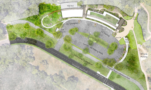
With construction of the new Frautschi Center, Lakeshore Nature Preserve will have a new “front door.” Due to the placement of the new building, the current service entrance and drive at the stone wall will be converted to a pedestrian-only path (except for emergency vehicles).
Maintaining a service road near the front entrance is not feasible or the best solution for a variety of reasons, including safety, congestion and presentation. Eliminating vehicle traffic at this location removes a vehicle access point and service road for the Preserve.
A service entrance and road is needed to provide necessary access to support the 300-acre Lakeshore Nature Preserve, as well as the rest of UW–Madison’s campus.
The Preserve requires a road to:
- Enable operations that may require larger vehicles:
- Removing trees only when necessary.
- Regrading and maintaining paths.
- Servicing pit toilets.
- Allow Waste and Recycling and Grounds operations in the Preserve.
- Access the campus maintenance yard for Preserve and campus needs.
- Provide researcher vehicle access.
Proposed solution
Expand the current garden road to become an improved service road with footpath along existing route.
A gravel footpath (no vehicles) and gravel service road, separated by a fence, would follow the current garden road’s path, providing an entrance for vehicles to service the Preserve and campus. It also maintains access to the campus maintenance yard. Additionally, separating modes of travel addresses safety concerns. Currently, a single road is used for intermingled vehicle, pedestrian, bike, and gardener traffic.
Several alternatives were evaluated but ruled out at the time, due to greater disruption to the natural environment and other undesirable impacts.
The Lakeshore Nature Preserve 2023 Master Plan calls for the garden road to be paved; however, UW-Madison is choosing to use gravel, instead.
If you would like to provide feedback or ask questions, please email communications@fpm.wisc.edu.
If you would like to receive major project updates and announcements, please subscribe to the Lakeshore Nature Preserve Service Road and Entrance update email list by sending a message to communications+lnp@fpm.wisc.edu.
What happens next?
- UW-Madison will move forward with an Environmental Impact Statement (EIS), anticipated to take up to 12 months. The EIS will evaluate the environmental impact of the proposed project and assist the team in the final design. Moving to an EIS means there is not a final Environmental Impact Assessment (EIA). Instead, the draft EIA becomes the basis for an EIS. However, FP&M has requested the consultant include factual updates to the Draft EIA.
- The service road is proceeding on its own timeline, separate from the Frautschi Center’s construction. This will allow time to continue to explore needs and address concerns. The service road project is being paid for by university funds, as planned.
- FP&M Physical Plant and Preserve staff are working collaboratively to reduce the size of the campus maintenance yard and explore additional long-term options.
Maintaining access to serve the Preserve and campus
Proposed road
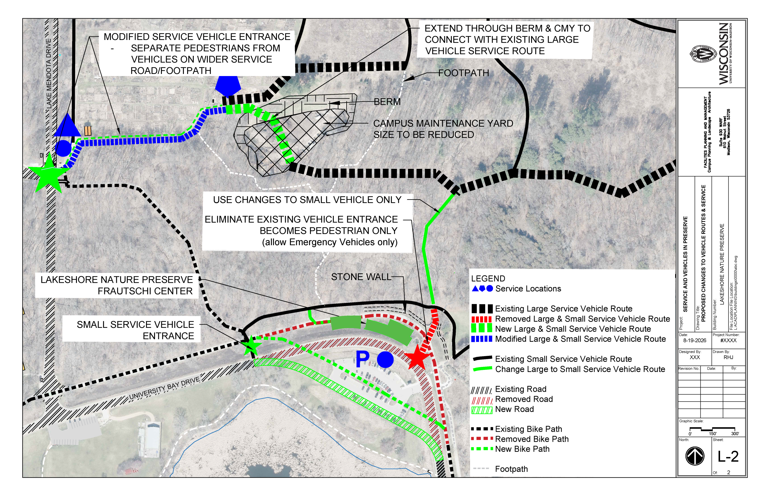
In the map to the right, the bright red star and dashed path represents where authorized vehicles currently enter the Preserve. However, with the new Frautschi Center, this route will be transitioned to pedestrian only, which will address safety, congestion and aesthetic concerns.
In this proposal, to maintain critical service access to the Preserve, authorized vehicles would traverse the dashed blue line, entering off of Lake Mendota Drive and separated from pedestrian, bike and gardener traffic. The dashed green line continues through the campus maintenance yard, where it meets with existing service roads that provide further access.
Recently, UW–Madison learned that cremated remains from the Body Donor Program may have been buried or scattered in the Lakeshore Nature Preserve. The university has been unable to find documentation confirming the specific location of cremated remains in the Preserve.
However, since this information became available, UW–Madison staff have consulted with the Wisconsin Historical Society (WHS) to assess the situation, and WHS has designated a berm in the Preserve as an uncatalogued burial site. The university will continue to work with WHS, including completing an archaeological survey as appropriate, as part of the Environmental Impact Statement (EIS) required as part of development activities in the Lakeshore Nature Preserve. The EIS will evaluate the environmental impact of the proposed project and assist the team in the final design. UW–Madison will not disturb the berm during this consultation.
Regarding the service road, as further needs, engineering constraints, and additional factors are identified, design features may change. This is common to capital projects.
Evolving to meet changing needs and conditions
How master plans help us plan for the future
Master plans serve as a tool to help establish a long-term, continuing framework to help guide future plans, improvements, and generally how the built and natural environment can support UW–Madison’s mission and community. FP&M is leveraging the existing Lakeshore Nature Preserve Master Plan and Willow Creek Master Plan as guides, and current recommendations address many of the concerns in the plans. However, master plans are not intended to be mandatory checklists but frameworks in a changing world. For examples of when the master plan no longer suited current or future needs, please click through the table below.
The Preserve Master Plan discusses an alternate access route to the campus maintenance yard, which the proposed design addresses.
It also recommends improvements to the garden road, including paving (see pages 76- 77 of the plan for “Recommended Trail Types” map). However, UW-Madison would plan to use gravel, instead.
The 2023 Preserve Master Plan calls for both relocating the campus maintenance yard and also for maintaining its presence. While strongly advocating removal, the plan also calls for continuing to store materials, such as firewood, in the same location.
The plan assumes the yard is only used for Grounds purposes; it serves UW-Madison’s campus, including Preserve operations.
Although the Preserve Master Plan recommended the yard be removed, it did not identify a new location. The 2015 Campus Master Plan also did not include steps to facilitate relocation of the yard. Until this enabling step is completed, the yard cannot be removed from the Preserve.
The upcoming Campus Framework Plan will include studying alternate locations for operations at the campus maintenance yard. In the meantime, UW-Madison is taking a holistic look at operations conducted in the yard to minimize and improve the space.
The Preserve Master Plan recommends improvements around the berm (to create a gathering shelter and storage sheds) and to the berm (to address runoff issues) but does not mention the possible presence of cremated remains in the berm, which could affect plans for disturbance.
Recently, UW–Madison learned that cremated remains from the Body Donor Program may have been buried or scattered in the Lakeshore Nature Preserve. The university has been unable to find documentation confirming the specific location of cremated remains in the Preserve.
However, since this information became available, UW–Madison staff have consulted with the Wisconsin Historical Society (WHS) to assess the situation, and WHS has designated a berm in the Preserve as an uncatalogued burial site. The university will continue to work with WHS, including completing an archaeological survey as appropriate, as part of the Environmental Impact Statement required as part of development activities in the Lakeshore Nature Preserve. UW–Madison will not disturb the berm during this consultation.
The Preserve Master Plan calls for removing the main entrance’s foot path. Instead, this path will remain in use for users and be separated from large vehicle traffic.
Frequently asked questions (FAQs)
FP&M has received dozens of questions and comments from many members of the public, at the Draft Environmental Impact Assessment public meeting, in writing, and during conversations. We thank our community stakeholders for this input and have collected these questions and answers in the list below. If you have a question that has not been answered, please email communications@fpm.wisc.edu. Questions sent to other UW-Madison units will be forwarded to FP&M for response.
Note: The questions below are grouped into categories and formatted as collapsible accordion panels, due to the large volume of content. However, if you prefer to view all questions and answers in one printable document, please view the PDF that was sent to commenters of the draft EIA.
About the service road
This is an accordion element with a series of buttons that open and close related content panels.
What is the design of the new service entrance, road and path?
Currently, the proposed design specifies:
Service road
- The service road would be gravel and 14 feet wide. (The existing road is 9 feet wide.)
- It would be 860 feet from the entrance to its terminal at the campus maintenance yard.
- It would follow the current path of the garden road along the north edge (perimeter) of Bill’s Woods, before turning into the campus maintenance yard. The road would not run through the woods.
- No lights are planned to be installed as part of this project.
- Speed limit signs are planned to be installed on the road.
The proposed service entrance/road has been designed to have as minimal impact as possible (following the same path as the existing garden road, not cutting through Bill’s Woods, not creating new roads where there are none, not adding to fragmentation).
Foot path
- The gravel footpath would be 7 feet wide until it reaches the concrete weed pad, where it would remain 10 feet wide.
- To be improved: Erosion on the path heading north from the entrance and poor surface conditions on the path at the south edge of the gardens would be improved.
Separation by fence
- There would be a 3-foot space between the road and footpath with gravel and a fence.
- The proposed fence would be chain link, installed 4 inches off the ground, so small wildlife could pass under it. Most birds would be able to fly over it, and deer would be able to jump over the fence.
However, as further needs, engineering constraints, and additional factors are identified, design features may change. This is common to capital projects.
What alternate locations have been considered for the service entrance and road?
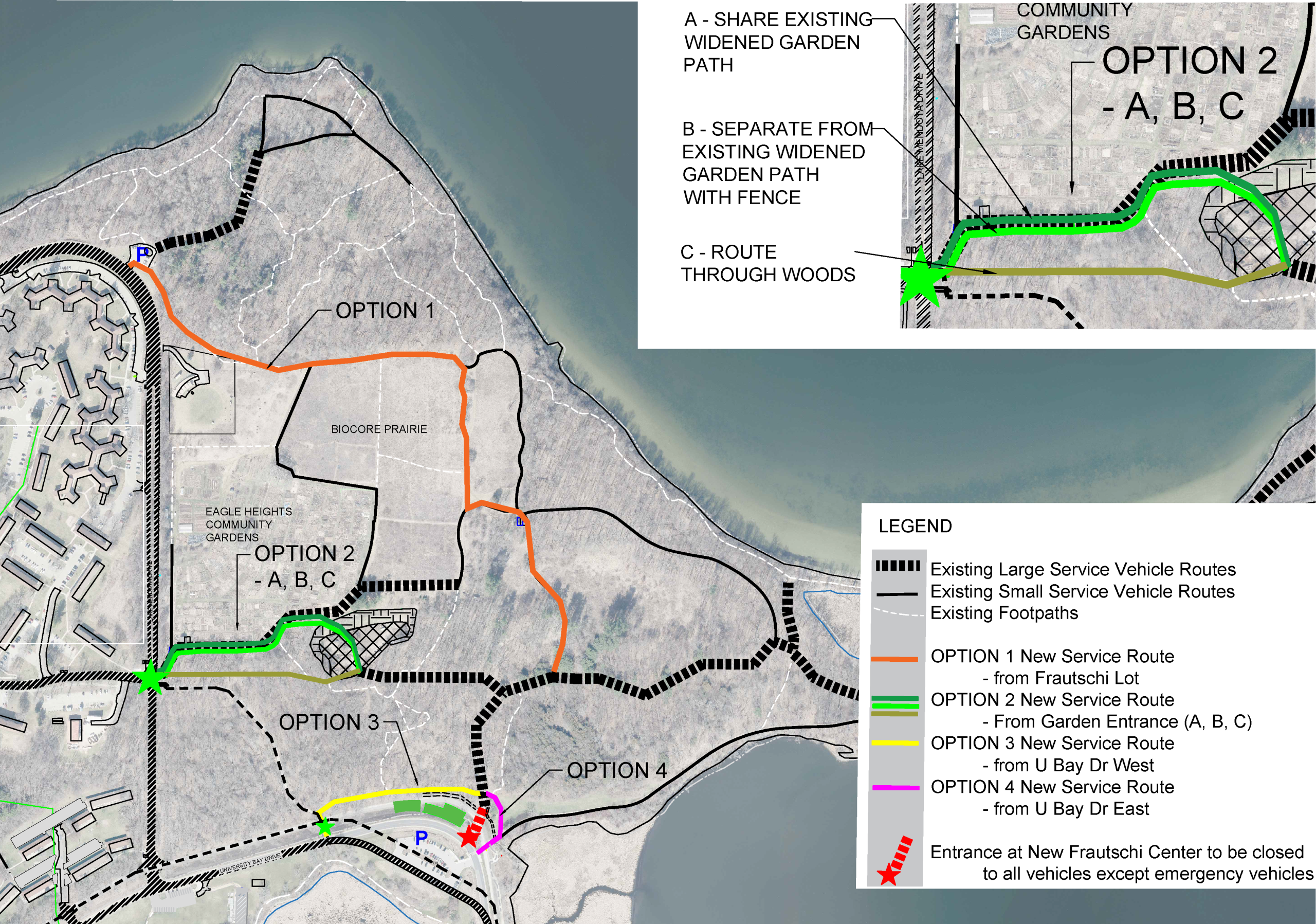
With construction of the new Frautschi Center, Lakeshore Nature Preserve will have a new “front door.” Due to the placement of the new building, the current service entrance and drive at the stone wall, marked in red in the map to the right, will be converted to a pedestrian-only path (except for emergency vehicles).
Maintaining a service road near the front entrance is not feasible or the best solution for a variety of reasons, including safety, congestion and presentation. Eliminating vehicle traffic at this location removes a vehicle access point and service road for the Preserve — including the only road to the campus maintenance yard.
A road that provides access to the Preserve for both large service vehicles (large trucks, trailers, cherry pickers, etc.) and small vehicles (utility vehicles, small vans, etc.) is needed. Five possible options were considered:
- Orange line – Create a new service road from the small parking lot on Frautschi Point around Biocore Prairie, south to connect with existing roads. This option widened a large portion of existing small vehicle roads to roads that could handle larger vehicles. It affects more of the Preserve, clears more trees, and creates more road than the selected option. It is also the least direct option to the campus maintenance yard.
- Green lines – Create access for service vehicles at the Eagle Heights Community Gardens entrance, off Lake Mendota Road. This option included three alternate versions:
- Widen the existing garden road and have large service vehicles share it pedestrians, cyclists and gardeners. Although this option gave access to the maintenance yard, it also mixed increased service vehicle traffic with other users.
- Selected option: Following the same path as the existing garden road, create a separate gravel road and gravel footpath (with a fence between) that traverses the perimeter of the woods to provide direct access to the maintenance yard and improve safety by separating (increased) service vehicle traffic from other users. It also provides an opportunity to improve the footpath, removes fewer trees than other options, and removes traffic from the Preserve’s front entrance.
- Create a service road through the woods, following a previous utility line path. Although this provides a straight path to the campus maintenance yard, it creates a new road directly through the woods, which would remove many trees and create fragmentation.
- Yellow line – Create a new service road from University Bay Drive (west of the new Frautschi Center) that connects with the existing roads. Because a current road does not exist here, this would clear many trees at the front of the Preserve — more than the selected option. It would also create fragmentation. Vehicle traffic would be increased near the front entrance of the Preserve and the Frautschi Center, as well as along the pedestrian trail north of the stone wall.
- Fuchsia line – Create a new service road east of the new Frautschi Center from University Bay Drive that connects with existing roads. Similar to option 3, this option removes more trees than the selected option (and at the front door of the Preserve), adds traffic to the front entrance of the Preserve and Center, and creates fragmentation.
UW-Madison will move forward with an Environmental Impact Statement (EIS), anticipated to take up to 12 months. The EIS will evaluate the environmental impact of the proposed project and assist the team in the final design.
Would converting the garden road to a new service road/entrance and foot path be noisy or noisier? What will impacts be to other users of the area? On nature?
Overall road noise at the Preserve would not increase, as ongoing operations are not expected to increase due to this project.
With the proposed design, service vehicles would travel less distance through the Preserve, as the new road would be 860 feet long, while the existing service road (that starts by the front entrance) is 1,200 feet long.
However, because some operations (including vehicle-based operations) would be relocated from the front entrance of the Preserve to the new service road and entrance, the area adjacent to the new road and entrance could have additional noise.
Impact on users
We acknowledge that vehicle traffic and especially the “back-up” safety beepers on our work vehicles can be disruptive to those visiting the Preserve. We are committed to reducing the number of vehicles accessing the yard and their frequency. Preserve and Grounds staff are also investigating ways to increase the efficiency of how the yard is used, including plans to shrink the size of the yard, starting this fall.
Impact on nature
We know that vehicle noise can affect birds and mammals in a variety of ways and can vary by species, life history, phenology, etc. Similarly, the scale of the effect depends greatly on the type of noise, frequency interval, location, time (daytime vs night), and many more factors.
Overall
While the impact of noise pollution from vehicles accessing the campus maintenance yard has not been studied, we are committed to reducing the frequency of vehicles entering and leaving the yard. When they need to use the new service road, vehicles will move slowly, not idle in the yard (to also minimize greenhouse gas emissions), and use the space efficiently to minimize the “back-up” safety beeping. This should actually reduce operational noise overall in the Preserve.
Who uses the garden road currently?
Vehicular access to the existing garden road is blocked by a locked gate. Authorized users who have the combination to open the gate are:
- Biocore Prairie manager
- Bird banding station researcher
- Bucky’s Restrooms (to service portable toilets)
- Eagle Heights Community Gardens (EHCG) gardeners and registrar
- Friends of the Lakeshore Nature Preserve’s bluebird and purple martin house managers
- FP&M Lakeshore Nature Preserve staff
- FP&M Environment, Health & Safety fire contact
- FP&M Campus Planning & Landscape Architecture contact
- FP&M Physical Plant
- Grounds supervisors – Staff use the existing garden road to access their nursery area very rarely, as they are not actively growing anything there.
- Currently, no traffic going to the campus maintenance yard uses the garden road to access the yard because it does not go to the yard.
- UW Housing
- Supervisors (including UW Housing Grounds supervisors)
- Dining staff
- People’s Farm and greenhouse community managers
- UW Police Department
- Village of Shorewood Hills leaf delivery driver
How will a new road address current Lakeshore Nature Preserve operations being scattered around campus?
The Frautschi Center’s construction allows Preserve staff to consolidate many of their operations into one location directly at the Preserve. A new service entrance and road would maintain access to existing activities in the Preserve, including firewood provision and trail maintenance.
A service road also provides access to the Preserve for tree maintenance, which requires large arborist trucks that will no longer be able to use the front gate where pedestrians are concentrated.
Service road safety concerns
This is an accordion element with a series of buttons that open and close related content panels.
How much vehicle traffic is there?
The current average traffic rate is 15 vehicles per day, mostly between 2 and 3 pm. There are limited higher traffic days during spring and fall mulching and leaf operations.
Would there be increased traffic in this area with the new service entrance and road?
Yes, the intention is that campus maintenance staff and Preserve staff who need access to the Preserve and campus maintenance yard would use the separated service road, while pedestrians would use the path on the garden side of the fence. As stated previously, there will be an effort to reduce overall traffic in the area and on the service road.
How would you keep the intersection safe with large trucks traveling (north on Lake Mendota Drive) up the hill and making a right turn, an immediate left, and another immediate right?
Vehicles entering from the south (up the hill) on Lake Mendota Drive would have a stop sign before they turn right into the driveway. This driveway would be separated from the pedestrian entrance by a fence that starts within 15 feet of Lake Mendota Drive, all the way down the service road.
Vehicles would proceed on the service road for about 100 feet and stop to open a gate to continue on the service road, which is separated from the Garden path by a fence. The bike path would be separated from the drive entrance and would have a sidewalk-like crossing to cross the driveway.
Would adding a fence between the footpath and service road cause children to be in danger because they go around or over it and are on the wrong side? Will adding a fence eliminate “desire paths” Eagle Heights Community Gardens (EHCG) users (especially children) use?
The proposed fence is currently planned to be a 4-foot-tall chain link fence that would extend from the pedestrian entrance where gardeners cross Lake Mendota Drive to the campus maintenance yard, so there should be minimal chance to get on the service road side of the fence.
Adding a fence would eliminate direct movement between the new service road and pedestrian path. Desire paths would be further discouraged by users being directed to terminal fence ends and/or breaks where crossings would be safer.
How would you ensure pedestrians cross over onto the gravel footpath and stay off the gravel service road?
All pedestrians would enter the garden to the left side of the fence. A pictorial sign would direct pedestrians to the left and vehicles to the right.
How would you keep pedestrians accessing the gardens who cross Lake Mendota Drive safe with more large vehicles entering the area?
Pedestrians currently use the crosswalk at the north side of the intersection of the driveway and Lake Mendota Drive. If that path is used, then pedestrians and vehicles using the service entrance/road would not mix.
Are there plans to implement traffic calming devices (e.g., curve, cattle guards, speed bumps)?
This will be considered as part of the design of the road.
How would you keep the new entry at the top of the steep hill — especially with a new stop sign safe when it is snowy and icy?
Transportation Services investigated the crash history of this intersection from 2017 to August 2026. None of the crashes indicated property damage from cars getting stuck going uphill. The slope at the stop sign would be 2%; 50 feet back from the stop bar (the white line on the pavement indicating where to stop) is 4% and 100 feet back is 7.5%. Transportation Services anticipates cars that stop at the stop sign would not get stuck trying to start again.
Transportation Services also met with Madison Metro to see how this stop sign would work with their operations; they agreed that the placement of the stop bar should not be an issue with how flat the slope is there. Transportation Services also reached out to City of Madison Traffic Engineering, who supported a stop sign on the south leg, due to the new intersection geometry/crossings.
Stopping sight distance is 143 feet at 25 miles per hour at a 6.5% uphill grade. If a stop sign were not to be placed, Transportation Services would anticipate that it would be difficult to see pedestrians/bicyclists in the new crossing on the southern leg. If Transportation Services starts to see an increase in property damage/incidents from vehicles getting stuck on the hill, they would re-evaluate the stop.
Would a new road help (or hinder) unauthorized access to the Preserve? Will the service road create an unattended entrance (enabling private vehicles, bikes and pedestrians to access the Preserve)?
The proposed service road would have a locked gate, which would require users to secure it each visit for it to remain effectively locked.
We do not anticipate access to the Preserve to be any greater than the existing unattended front entrance into the Preserve at the stone wall.
Effects on adjacent users
This is an accordion element with a series of buttons that open and close related content panels.
How would bicyclists be affected?
The existing bike path to the south of the Eagle Heights Community Gardens would remain in the Preserve but have a safer, more separate exit to Lake Mendota Drive.
Would current users still be able to access their gardens and the prairie?
Eagle Heights Community Gardens, Biocore Prairie, Housing Dining & Culinary Services Farm, and People’s Farm users would still be able to access the gardens and prairie.
What would the effects be on Eagle Heights Community Gardens (EHCG)?
During construction
There would be noise, dust and equipment on site during active construction. Once a contractor is selected, FP&M would work with them to try to minimize effects as much as possible.
After construction
A gravel road would traverse the same path as the existing garden road. There would also be a gravel path, separated from the road by a fence, which would be 4 inches off the ground, to allow most wildlife to pass.
The footpath gardeners use would be rebuilt as part of this project and would be in better condition than the current garden road. It would no longer have vehicles on it, because it would be separated from the new service road. Current designs call for the path to be narrower, 7 to 8 feet instead of 9 feet wide — which would help limit tree removal.
This project would not change EHCG’s footprint or plot layout. Access to the Gardens would still be controlled, via gate (and new fence). Gardeners would still be able to access their amenities, including the EHCG shed, port-a-potties, as well as the compost, leaves and other organic matter in the southeast corner of the gardens.
Would the service road plan block vehicle access to EHCG porta-potty and recycling bins?
The vehicles for these uses would have a gate to enter the garden’s path system at the entrance and be able to function as they do today. Additionally, this summer, FP&M Waste and Recycling is experimenting with smaller trash bins, which would mean a much smaller truck could service those bins.
Would the working areas of the weed/mulch piles of the EHCG be less safe?
No, this would remain the same. Gardeners currently navigate this area during leaf and weed service, using a grass pedestrian route on the north side of the piles, instead of the gravel road. This solution would remain after construction of the road.
How would vehicles access EHCG, Dining Farm and People’s Farm?
Vehicles would access EHCG, the Dining Farm and People’s Farm through a gate that allows only those with the lock code to access the garden road heading north from the entrance. This is the same as current practice.
About the campus maintenance yard
This is an accordion element with a series of buttons that open and close related content panels.
Does UW-Madison need the campus maintenance yard?
Yes. Both FP&M Physical Plant Grounds and the Preserve (also a part of FP&M) need this yard.
For example, campus operations uses this yard for campus composting – turning leaves into compost for planting beds. This is also a storage location for various items.
The Preserve uses the maintenance yard primarily for storing firewood that has been split by Grounds for the three racks on Picnic Point that are used by the public at fire circles. The Preserve also occasionally uses the gravel pile in the yard to repair erosion gullies throughout the Preserve.
Currently, FP&M is working to reduce the footprint of the yard, but at this time, this yard is needed.
What is in the campus maintenance yard now?
Loose materials storage, compost operation, wood processing activities are stored in the yard. This includes wood, large stones, and crushed lime stone for the Preserve, as well as soil, sod, compost, back stock and more for campus operations.
How are you improving the campus maintenance yard?
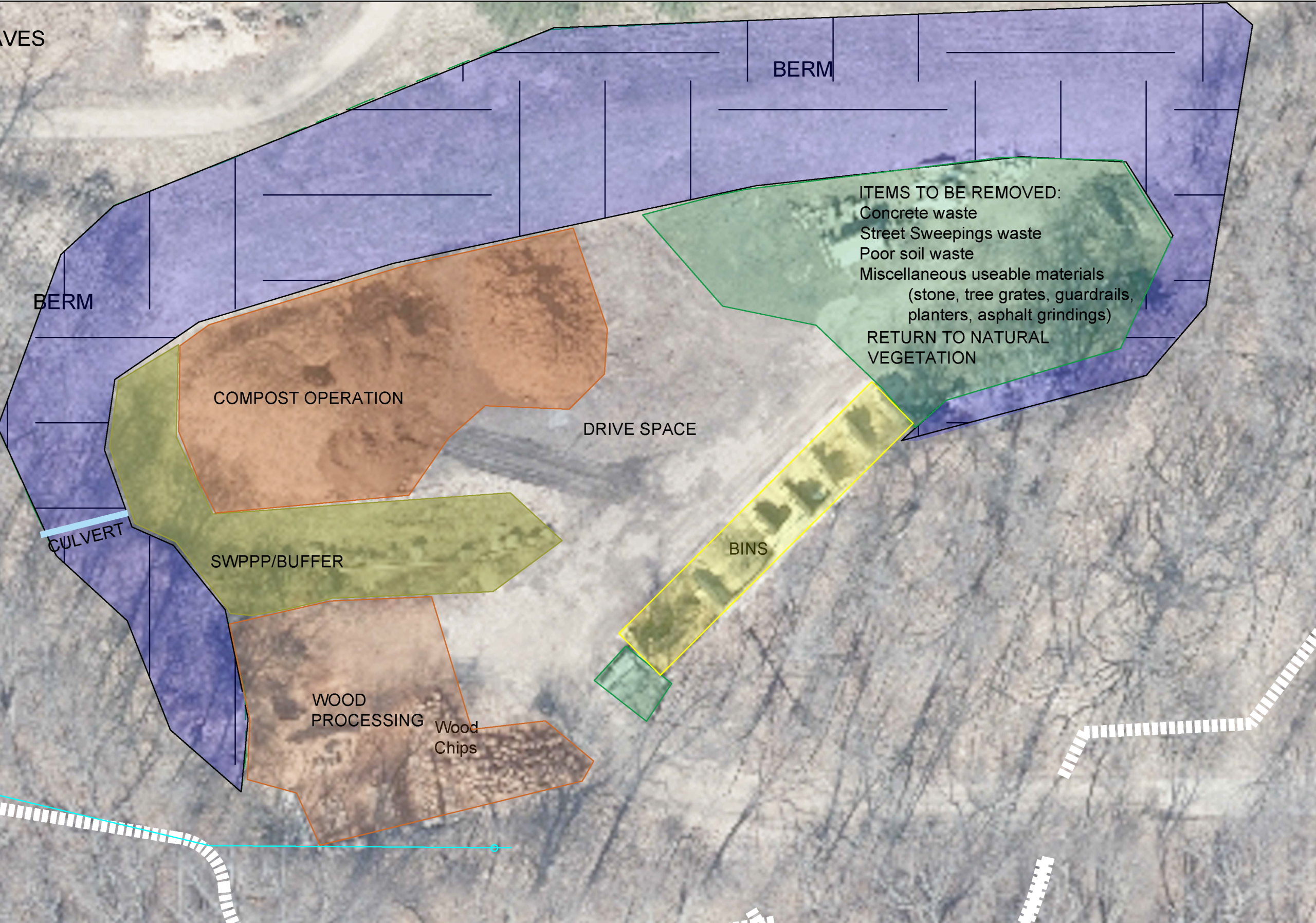
Click the map above to view larger in a new browser window or tab.
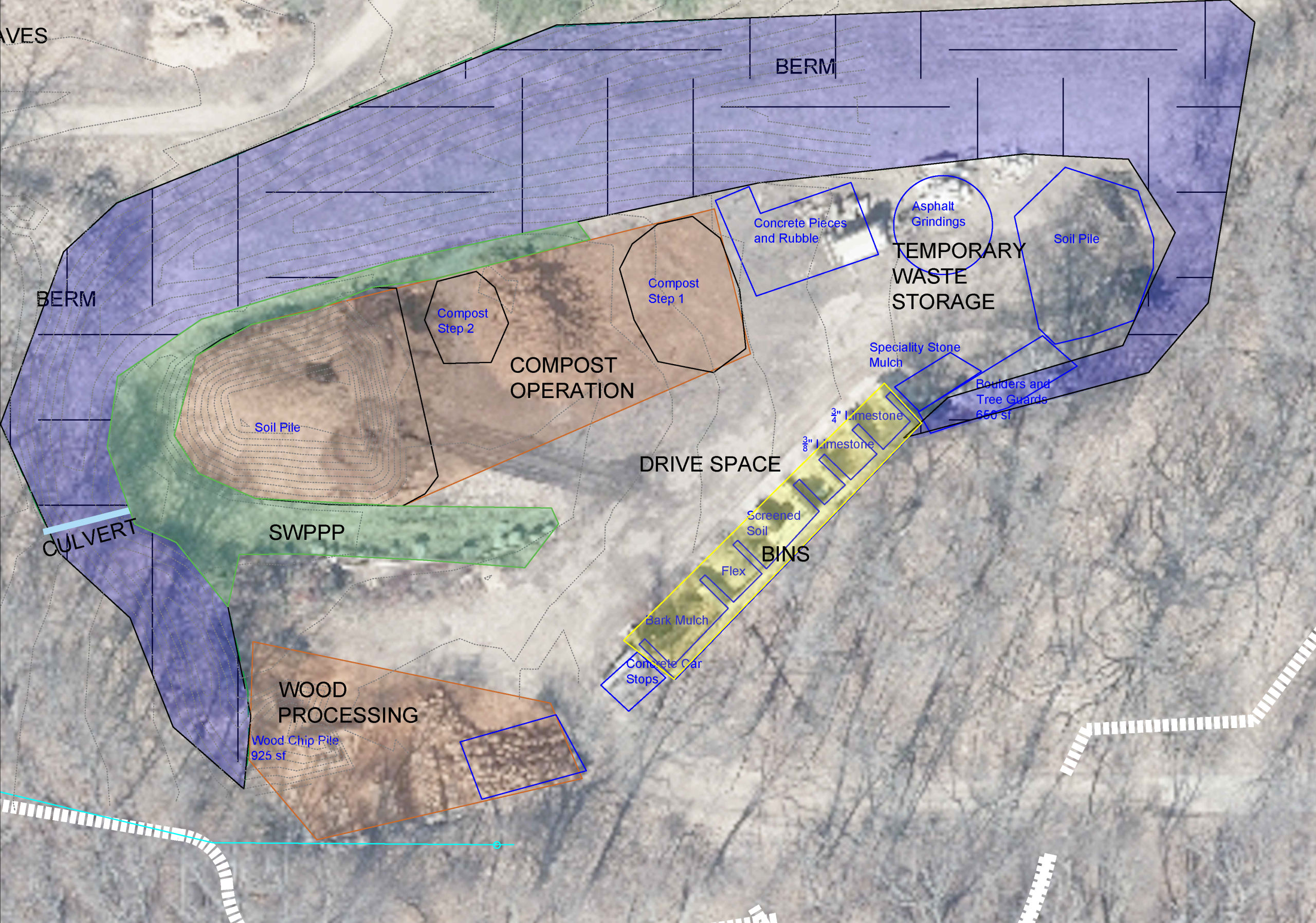
Click the map above to view larger in a new browser window or tab.
FP&M Physical Plant Grounds leaders are working closely with Preserve staff and others to begin removing items that can be recycled, reused, or disposed of. This work is scheduled to start by October 2026. Concrete waste, poor soil, and various usable materials that are currently stored in the yard will be removed, ultimately shrinking the footprint of the yard. The spaces that used to house the removed items will be returned to natural vegetation.
In addition, planning is underway to rethink what landscaping materials are critical and what can be relocated.
Long-term, this area and possibilities for full relocation will be addressed as part of the upcoming Campus Framework Plan.
If you move the campus maintenance yard, do you still need the road?
Yes, the road will still be needed to support Preserve operations and enhance safety in the surrounding area.
A new road is necessary to provide a service entrance to the Preserve. Due to the placement of the Frautschi Center, the current service road at the stone wall will be converted to a pedestrian- and emergency-only path. Maintaining a service road (and entrance) near the front entrance is not feasible or the best solution for a variety of reasons, including safety, congestion and presentation.
A service road is needed to provide necessary access to support the Preserve. While some operations can be completed with smaller vehicles that can traverse smaller roads, there are specific caretaking tasks that require larger equipment. These include removing trees, service of pit toilets, custodial operations, and maintenance of paths.
Splitting pedestrian and vehicular traffic enhances safety. Currently, a single road is used for vehicle (including large service trucks), pedestrian, bike and gardener traffic. With the addition of the service entrance/road, we have the opportunity to eliminate these conflicting modes and fully isolate vehicle traffic in this area.
Were relocation sites considered for the campus maintenance yard?
Six sites (as well as combinations of the sites) on the west side of campus were considered as sites for the campus maintenance yard. At the time of analysis, no solution solved the issue without creating more problems.
Did you consider having multiple sites instead of one?
This alternative was considered, as materials are already stored and staged in multiple sites across campus to accommodate natural materials, replacement and back stock, amenities, recyclables, equipment and more.
No combinations of sites were a good fit at the time. In addition to other campus operations, the maintenance yard also supports Preserve work, as an operations area for splitting and storing firewood, which will continue to be needed because the future Frautschi Center yard will not fully accommodate these needs.
Are there many existing places on campus where you can relocate materials now?
When last studied, existing sites did not meet specialized operational needs of the Preserve and campus, were already reserved for other uses, and/or were not large enough for truck movements. However, FP&M continues to consider alternatives and work to find ways to collaborate with campus partners.
Can the Barley Malt building site be used?
It was one of the considerations, but this site is earmarked for other uses.
Can you work with other campus organizations (e.g., departments, Housing, Athletics) to accommodate uses?
FP&M regularly collaborates with partners on and off campus, and we are currently discussing additional opportunities to share resources, including space for campus material storage and staging.
Will this project cause the yard to grow?
No, this project will not increase the yard size, and there are no plans to increase the size of this yard in the future. In fact, starting in October, staff will begin removing materials, shrinking the size of the yard.
If you do not find a new location now, what are future plans?
Right now, Physical Plant and Preserve staff are partnering to remove some of the materials from the yard, as well as cleaning and improving the aesthetics of the yard. Additionally, the university is looking at potential options to relocate some of the activities that take place in the campus maintenance yard.
Long-term, this maintenance yard (as well as other campus operational needs) will be considered in the upcoming Campus Framework Plan. Removing the yard from this site will be considered.
Ecological concerns: General
This is an accordion element with a series of buttons that open and close related content panels.
What effects on the Preserve are expected due to the service entrance and road?
The proposed road would remove 0.53 acres of marginal wooded area and associated herbaceous understory plants. The removal of trees would reduce the carbon sequestration capacity in this area of the Preserve. It would also create an edge that is 14-16 feet further to the south into Bill’s Woods. Stormwater flows would likely be increased, potentially causing more erosion in Bill’s Woods.
When other locations and designs for the road were investigated, this option was the least disruptive to the Preserve’s ecology.
Will the road introduce more invasive (flora and fauna) species? Will having more "edge" "increase management needs due to invasive species?
It is unlikely that the road would introduce new invasive species that are not already in the area, but it is possible that the construction disturbance will create new areas for invasive species to spread. Staff will manage this area similar to the rest of the Preserve.
Once complete, the proposed project would create very little new edge, but it would move edge 17 feet closer to the interior of Bill’s Woods.
Why does the Draft EIA state that portions of Lakeshore Nature Preserve are "undeveloped"?
As part of its mission, Lakeshore Nature Preserve will remain largely undeveloped — meaning simply it is not used for building, farming, industry, etc. However, its undeveloped status does not mean it is viewed as potential for development or is waiting to be developed.
Ecological concerns: Trees and other plants
This is an accordion element with a series of buttons that open and close related content panels.
Would the road negatively impact fragmentation?
Because the proposed service road would be constructed immediately adjacent and along the southern edge of the current gravel garden, little new edge would be created.
However, we recognize that an expanded service entrance/road would, in effect, move the current fragmentation effects to the south and closer to the interior of Bill’s Woods. (Road locations that went straight through Bill’s Woods were not selected to avoid bisecting the woods.)
Native woodland plant species that are already found in Bills’ Woods would be planted along this new edge in an effort to grade the plant communities with those found in Bill’s, stabilize the soils, and compete (at least initially) with non-native plant species. Monitoring and management of invasive species along this strip would be incorporated into the ongoing restoration work at Bill’s Woods.
How much of the woods would be removed?
With the proposed design, the area that would be cleared would be 0.53 acres.
How many and what types of trees would be removed?
The 10 largest trees that would be removed are between 6 and 16 inches diameter at breast height (DBH). These include two of each:
- Eastern hackberry
- Shagbark hickory
- American elm
- Norway maple (non-native and invasive).
Additionally, there is one American basswood and one black cherry tree that would be removed.
Smaller trees (< 6” diameter at breast height or DBH) and tall shrubs would also be removed. Dominant species in this size class include sugar maple, boxelder, hackberry, oak (bur and white), and common buckthorn (non-native and invasive).
What would happen to the three young native grown oak trees (one near the porta-potty, one along south side of weed pile road west of culvert, one at south side of road across from weed pile)?
The young oak near the portable toilet (porta-potty) would be transplanted in the area. The other two would be removed.
Ecological concerns: Wildlife
This is an accordion element with a series of buttons that open and close related content panels.
How would wildlife be affected?
Wildlife would lose approximately 0.53 acres of marginal edge habitat. However, overall populations should not be affected, including nesting and feeding resources.
Would a fence be a deterrent to wildlife?
Barriers of any kind can be deterrents to movement of wildlife. Some wildlife would need to go under, over or around the fence when moving from Bill’s Woods to the north and vice versa.
However, the fence that would separate the road from the pedestrian path would be 4 inches off the ground so small wildlife can pass under it. Most birds would be able to fly over it, and deer would be able to jump over it.
At Preserve scale, (when considering the Preserve overall) the fence should not have an impact on wildlife movements.
How will migratory birds be affected?
Populations of migratory birds utilizing the Preserve during spring and fall stopovers should not be affected.
Would a barred owl family nesting there be affected?
We are not aware of a recent barred owl nest in the strip of trees along the garden road.
Would the fence move birds farther from gardening space (vs. current state)?
Some bird habitat would not be as close to the gardens as it once was. The fence itself would generally not affect birds.
Generally, we feel that the slightly increased distance of the forest line from the Eagle Heights Community Gardens would not affect the interaction of birds with food resources in the garden area.
What impact would the road have on Dutchman’s breeches that support the endangered Rusty Patched Bumblebee?
As the exact route of the service road has not yet been determined it is unknown if the project will affect that specific population of Dutchman’s Breeches. Additionally, Lakeshore Nature Preserve staff manages and restores habitat for many native spring ephemerals, including Dutchman’s Breeches, that support wildlife conservation throughout the 300 acres.
Ecological concerns: Stormwater, erosion, runoff and soil
This is an accordion element with a series of buttons that open and close related content panels.
Would there be erosion?
Erosion control will be implemented during construction. Post-construction, there would be rip rap (irregular shaped stones) at the end of the drain to help dissipate water movement.
Currently, there are three culverts with no rip rap at the outfalls. One would be eliminated, and two trench drains would pass the water. With this, more of the water would pass through the existing rain garden. During the EIS, we will study effects of this change to nearby areas.
Would there be soil compaction?
Only the road would be compacted. Construction vehicles will be restricted to as narrow a path as possible for construction.
Will having another “surface” negatively impact Bill’s Woods?
There would be more gravel surface for the road, which would result in slightly more runoff. It is designed to be sheet runoff rather than point runoff, which would cause less erosion.
What storm water controls will be included?
There are currently three culverts under the garden road.
With the proposed design, one of these would be eliminated, and two would be converted to trench drains that would extend under the garden path and the service road. The trench drains would drain into Bill’s Woods, same as the culverts do today. They would also be longer to accommodate the total width of the service road/entrance and footpath. There would be rip rap at the outfall of the trench drains to help dissipate the water flow; currently there is nothing at the end of the pipes.
Would this project help eliminate litter that accumulates on the downside of the yard culvert?
This project, as designed, would not touch that culvert. However, the operations team will look at what is causing that litter.
Are there records of plants, animals, maps of existing water flow and areas of present erosion and the effects on them?
For this project, a tree survey was conducted in the area along the south edge of the existing garden road. It identified trees larger than 6 inches diameter at breast height.
Cultural, archaeological and historically significant resources
This is an accordion element with a series of buttons that open and close related content panels.
Was an archaeological survey done?
Not for this project. A portion of Bill’s Woods (not including the campus maintenance yard and berm) has had a Phase I archaeological study completed in the past.
Will the new service road project disturb mounds or sites?
The proposed design does not disturb soil within the boundary of Paleo-Indian sites, including DA-0413, DA-1232 and DA-1233. DA-1232, the nearest site, is approximately 165 feet away.
At this time, the amount of additional stormwater created from the project has not been determined. Once this is established, the condition will be evaluated in consultation with the project archeologist and the Wisconsin Historical Society to determine whether additional stormwater measures are required.
Were there (donated) bodies buried in the berm?
Recently, UW–Madison learned that cremated remains from the Body Donor Program may have been buried or scattered in the Lakeshore Nature Preserve. The university has been unable to find documentation confirming the specific location of cremated remains in the Preserve.
However, since this information became available, UW–Madison staff have consulted with the Wisconsin Historical Society (WHS) to assess the situation, and WHS has designated a berm in the Preserve as an uncatalogued burial site. The university will continue to work with WHS, including completing an archaeological survey as appropriate, as part of the Environmental Impact Statement required as part of development activities in the Lakeshore Nature Preserve. UW–Madison will not disturb the berm during this consultation.
Note these are not the same as a Native American burial site or mound.
Have you reached out to the Ho-Chunk Nation?
Because this project does not disturb a known archaeological site, alerting the Ho-Chunk Nation is not part of the required process. However, the draft EIA was sent to the Ho-Chunk Nation, and UW-Madison will also provide the draft EIS for comment.
Funding
This is an accordion element with a series of buttons that open and close related content panels.
Are donor funds being used?
The EIA incorrectly implied donor funds were being used to create the service entrance/road. This will be corrected. We will be using university funds, as planned.
Are gifts given for Lakeshore Nature Preserve operations being used?
No gifts or donations to the Preserve are being used in the implementation of the service entrance/road.
Public involvement
This is an accordion element with a series of buttons that open and close related content panels.
How have the public and interested groups been engaged?
- In May, UW-Madison Facilities Planning & Management met with the Eagle Heights Community Gardens Garden Committee and Oversight Committee to give advance notice and answer questions about this project.
- FP&M, including Preserve staff, attended the Annual Friends of the Lakeshore Nature Preserve meeting, where Brad Herrick, the Preserve’s Director, presented an update, including this project. Staff were available after the meeting for further conversation.
- Public comment was sought for the Draft Environmental Impact Assessment. Notices were published in local newspapers and sent to the Lakeshore Nature Preserve email subscriber list. The Draft EIA was published online, and copies of the document were available for review at the UW-Madison College Library and Madison Central Library. The public review period was June 22-July 7, 2026, with an online public meeting at 5 pm on July 7. Comments could be submitted via comment form, email, and/or attending the public meeting.
- After the meeting, comments and questions were collected, organized and answered by subject matter experts. These constitute the majority of the FAQs on this page.
- FP&M plans additional future outreach, including another public meeting to discuss next steps and answer questions.
How can we provide input to the process? Does our feedback make a difference in this project/decisions being made?
Your feedback is an important part of this process. Public comment and input are taken into consideration with other data and factors, as decisions are made.
By providing comment on the draft environmental impact assessment (EIA), stakeholders have provided valuable input. As we continue with an environmental impact statement (EIS), you will have additional opportunities to provide comments.
Earlier in the process, UW-Madison staff met with leaders of the Friends of the Lakeshore Nature Preserve, the Eagle Heights Community Gardens Garden Committee and Oversight Committee. We plan to continue this engagement, as well as an additional in-person meeting open to the public.
At any time, you can also send an email to communications@fpm.wisc.edu, and it will be forwarded to the project team.
Why aren't you following the Lakeshore Nature Preserve Master Plan and Willow Creek Master Plan?
Master plans* are not intended to be mandatory checklists but frameworks in a changing world. FP&M is leveraging the existing Lakeshore Nature Preserve Master Plan and Willow Creek Master Plan as guides, and current recommendations address many of the concerns in the Master Plans.
Specific to the campus maintenance yard: Although the Lakeshore Nature Preserve Master Plan recommended the yard be removed, it did not identify a new location. It also did not take into consideration the service needs of the Preserve, omitting necessary Preserve service access. There is not currently a space to accommodate all of the uses of the yard in other locations on campus. Physical Plant and the Preserve are cooperatively considering reducing the use of the space. There are uses of this space that serve the Preserve and access is still needed for those activities.
The Preserve Master Plan does call for the garden road to be paved (see pages 76- 77 of the plan for “Recommended Trail Types” map); however, UW-Madison is choosing to use gravel, instead.
We have the opportunity in the upcoming Campus Framework Plan to explore and identify long-term solutions that meet the needs of both campus and the Preserve.
* Note: What are now called “framework plans” were previously called “master plans.” They are the same type of study.
Who has authority over these decisions (about the location of the yard and road)?
The Board of Regents holds ultimate legal authority over UW System physical assets under Wisconsin Administrative Code Chapters UWS 18 and UWS 21. Campus-specific land use decisions are determined by the Vice Chancellor for Finance and Administration and Associate Vice Chancellor for Facilities Planning & Management, working with campus stakeholders.
Can you make events in-person or hybrid? Can you make the feedback form digital?
The Draft EIA public event was held online to allow members of the public who may not be able to make it to a location (especially soon after a regular 8-5 workday) to attend. Online meetings are common practice for public sessions and many other organizations’ meetings, such as the City of Madison, UW-Madison, Dane County and more.
The form was available in paper or PDF (digital) format. However, we plan to work with consultants on fillable forms in the future.
How can I find out about future opportunities to provide feedback?
If you would like to receive major project updates and announcements, including public information meetings, please subscribe to the Lakeshore Nature Preserve Service Road and Entrance update email list by sending a message to communications+lnp@fpm.wisc.edu.
Where can I find the Draft Environmental Impact Assessment (EIA)?
It is currently available online.
Note that UW-Madison has requested a correction, which will be forthcoming.
Because UW-Madison is pursuing an Environmental Impact Statement, a final EIA will not be published. Instead, the draft will serve as the foundation of an EIS. This is standard practice.
Why did I have to provide my comments on the Draft EIA to Ayres Associates? Why was the comment period 15 days?
Ayres Associates is the independent, contracted consultant who is completing the EIA for this project. As part of this work, they seek public comment on the draft EIA, either written or at the public information meeting. This is standard practice.
The 15-day comment period is standard for Draft EIAs. However, if you have general comments, you can email communications@fpm.wisc.edu any time.
How will questions be answered/we hear about our feedback?
Answers to questions have been posted on the project website. Registered attendees of the public information meeting, as well as Lakeshore Nature Preserve email subscribers will be sent the answers via email. There will also be a public comment opportunity during the EIS process.
How do I provide further feedback?
Please email communications@fpm.wisc.edu. Questions sent to other UW-Madison units will be forwarded to FP&M for response.
If you would like to receive major project updates and announcements, please subscribe to the Lakeshore Nature Preserve Service Road and Entrance update email list by sending a message to communications+lnp@fpm.wisc.edu.
What comes next?
UW-Madison will move forward with an Environmental Impact Statement (EIS), anticipated to take up to 12 months. The EIS will evaluate the environmental impact of the proposed project and assist the team in the final design. Moving to an EIS means there is not a final Environmental Impact Assessment (EIA). Instead, the draft EIA becomes the basis for an EIS. However, FP&M has requested the consultant include factual updates to the Draft EIA.
The service road is proceeding on its own timeline, separate from the Frautschi Center’s construction. This will allow time to continue to explore needs and address concerns. The service road project is being paid for by university funds, as planned.
FP&M Physical Plant and Preserve staff are working collaboratively to reduce the size of the campus maintenance yard and explore additional long-term options.
Stay in touch
If you would like to receive major project updates and announcements, please subscribe to the Lakeshore Nature Preserve Service Road and Entrance update email list by sending a message to communications+lnp@fpm.wisc.edu.
Resources
Useful websites for background, updates and more
- Lakeshore Nature Preserve website
- About the Frautschi Center
- The Draft Environmental Impact Assessment (PDF; corrections to document pending)
- About Wisconsin Environmental Policy Act (WEPA)
- Lakeshore Nature Preserve 2023 Master Plan (PDF)
- Willow Creek 2022 Master Plan (PDF)
- UW–Madison 2015 Campus Master Plan
Stay in touch
If you would like to receive major project updates and announcements, please subscribe to the Lakeshore Nature Preserve Service Road and Entrance update email list by sending a message to communications+lnp@fpm.wisc.edu.
Questions? Please contact communications@fpm.wisc.edu.